
Erosion at Hengistbury Head Sep. 19, 2011 in Geography, Photos, Text
Walking along Hengistbury Head

Why is there a need to protect the coast at Hengistbury Head?
In order to prove the need to protect the Headland at Hengistbury Head I am firstly going to need to prove that erosion is currently taking place. I shall attempt to prove this with photographs, field sketches, old and new maps and I will ask the people who live nearby about their view on the erosion of Hengistbury Head. I will also need to see if there is any value of Headland to find out if it is worth protecting - I plan to get this information from various sources including the Internet, a survey we plan to carry out about the facilities used and what facilities we see and use on the day.
Methods of Fieldwork
| Method | Why | Problems/Limitations | Solutions |
|---|---|---|---|
| Erosion observation survey: By looking at the cliffs I will score the level of erosion | Used to ascertain the intensity of erosion at the chosen locations along the coastline to identify variations. Can be used to create a numerical comparison between different sites | Open to personal interpretation – not scientific Criteria may not be exactly match what I’m looking at | Will only be based on my opinion so some control to prevent bias. |
| Beach Profile: The angle of the beaches will be measured at 3 locations using clinomemeters. | The angle of the slope indicated the rate of erosion Determine if erosion is constant along the coastline | May have human error and if so it will be inaccurate If bad weather the wind and waves may distort the beach | Will get partner to check my work |
| Ecological Survey: Determine a value for the quality of the landscape | Will help determine the value of the landscape | May be inaccurate as its hard to determine accurately | Use a variety of opinions and average them |
| Survey: Ask a cross-section of people a range of questions | Will get an understanding of the different peoples view of the headland to understand its value | May not be enough people on the day due to it being Tuesday during school People may lie and supply inaccurate information | Revisit on another day preferably during the weekend |
| Bird Species Recording Sheet: Log the variety and quantity of birds found at Hegistbury | Used to collect the number of birds of each species there are | Incredibly boring and not very useful to anyone Birds will be hard to identify | Will be assisted by a member of staff who knows what he’s doing. |
| Field sketches: I will sketch the landscape at various stages, and annotate the key features looking for variation. | Provide an illustration of key geographical features and show erosion | May not be a good drawer | |
| Photographs: I will use photographs to record key geographical features along the coast | To get photographic evidence of erosion which is very accurate | Camera may not work on the day | We will share photos if needed |
Where is Hengistbury Head?
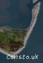
This satellite view of the Headland shows the vegetation on the Headland and the spit which has lots of expensive beach huts upon it which is a reason to protect the spit from erosion.
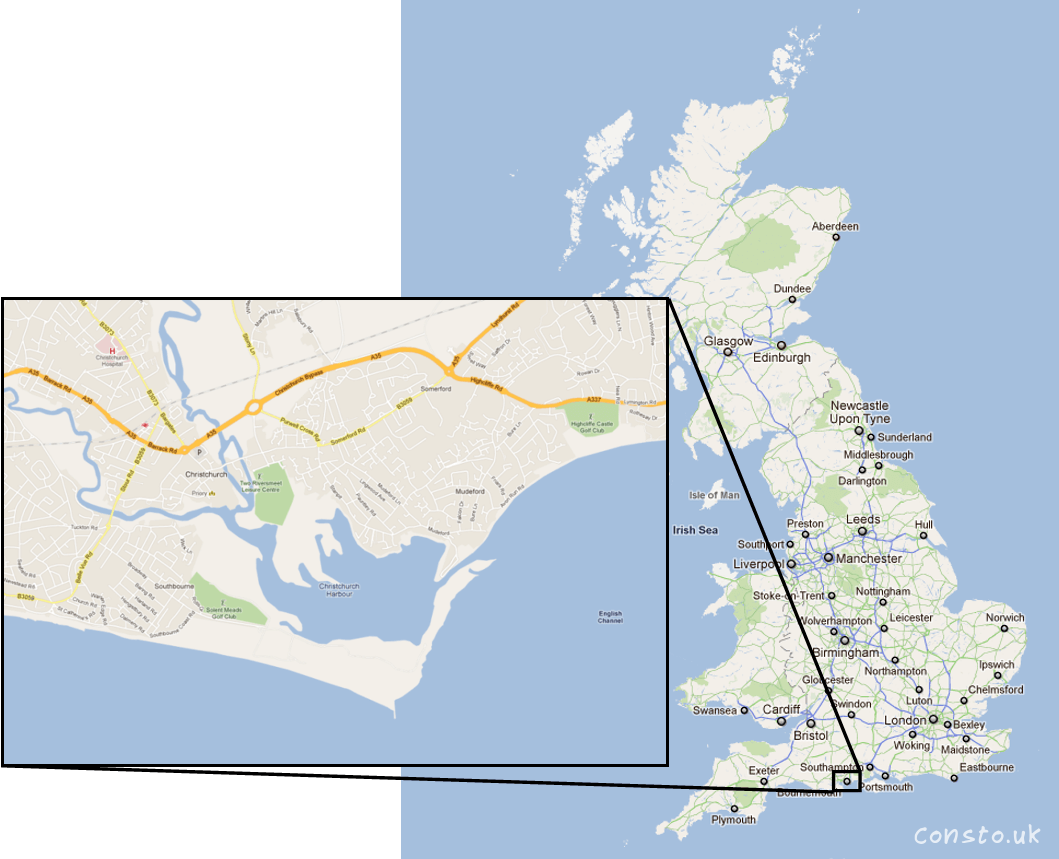
This map show where Hengistbury Head is located in the United Kingdom. The location is important due to the fact that it is in the warmer south, near to Bournemouth, a popular holiday destination for families.
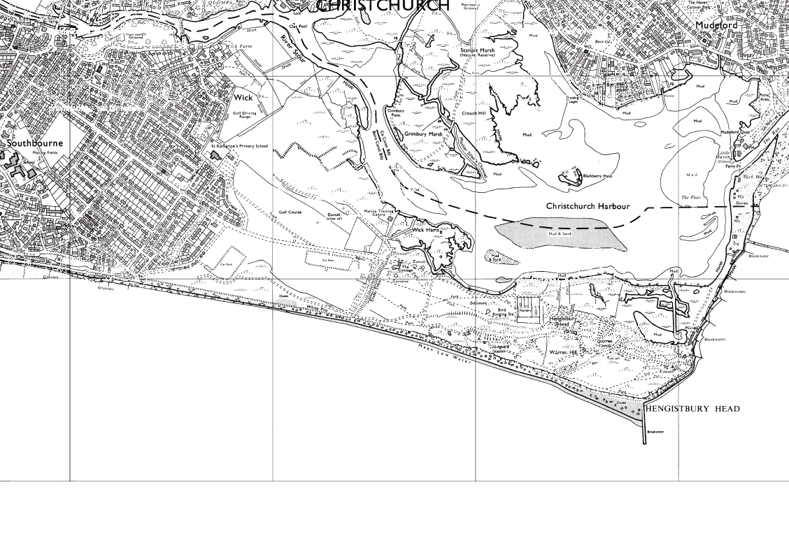
Maps of Hengistbury Head
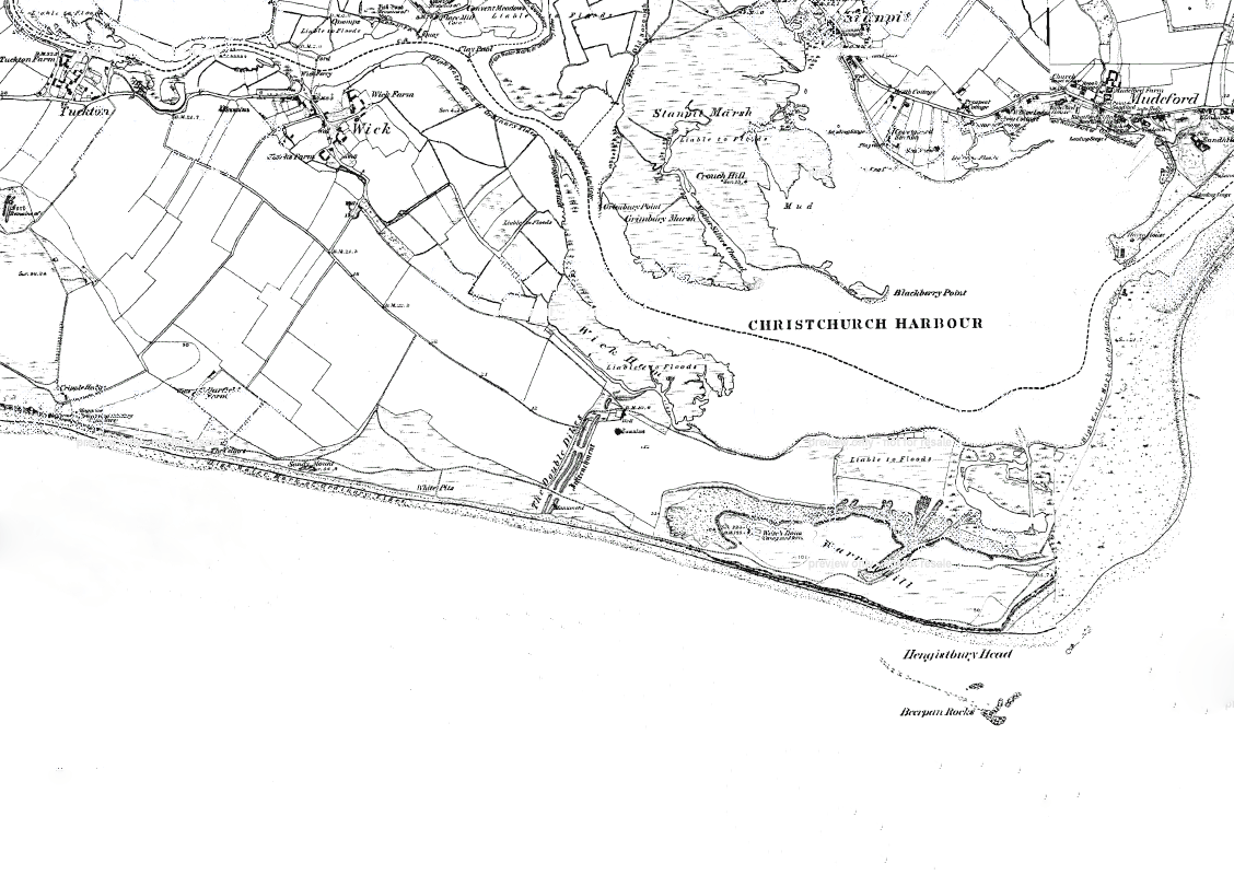
These 3 graphs have been taken over 118 years and they show how the Headland and Spit have changed over time.
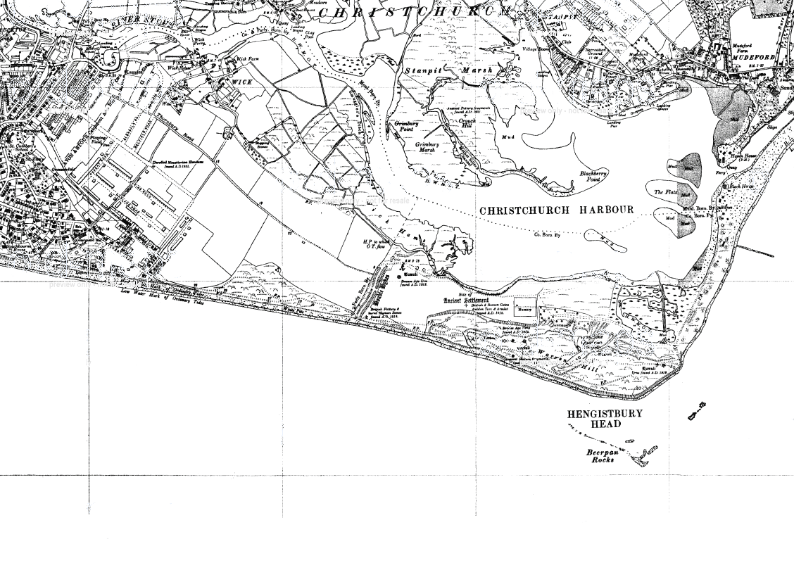
One of the biggest changes is how the spit has changed shape. In 1872 the spit was really wide, however as time has gone on it has been eroded away by the sea and y 1938 parts of it are only a third as thin as they were 66 years ago; this may have been caused by groynes being built further along the coast starving the spit of sand. In the 1960’s groynes were built to contain the sand which had been moved by long shore drift. As a result by 1990 the spit has shrunk by half due to the groynes trapping sand.
Also the shape of the Headland has changed due to mainly the Long groyne. This has caused a build up of sand on one side resulting in weakened cliff on the other. As a result numerous beach defences have been built.
Erosion Survey
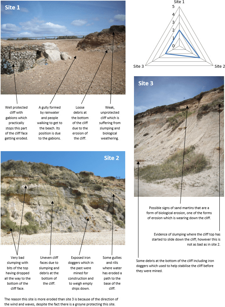
Photos

Where do people come from that go to Hengistbury Head?
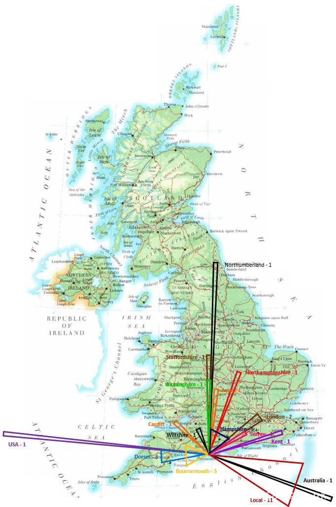
This graph shows where the people we asked to answer a questionnaire came from and how many people came from each location. This proves that Hengistbury Head attracts visitors from all over the UK and even some from further away such as Australia. These visitors bring money into the area which shows economically that the Headland may be worth protecting.
Ecological Score Chart
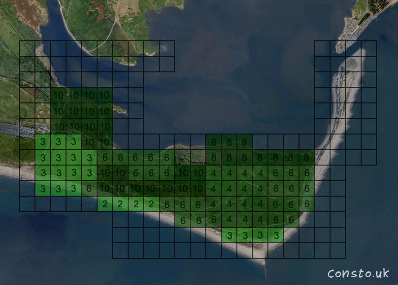
One of the ways we used to find out if there is any environmental value in the headland was by splitting a map into squares and then assigning them a value from 1 to 10 about how environmentally valuable they are.
| Score | Description |
|---|---|
| 1 | Tracks , pathways and roads |
| 2 | Buildings, Cereal Crops (Intensive Farming), Grassed areas |
| 3 | Grassland or meadows |
| 4 | Rough grazing, parks, orchards, verges, banks, boundaries and cuttings |
| 5 | Water meadows |
| 6 | Scrubland |
| 7 | Ponds, streams, ditches and other water courses |
| 8 | Wetlands, marshlands and reed beds |
| 9 | Hedges |
| 10 | Woodland and Sites of Special Scientific Interest |
Birds seen at Hengistbury Head
| Birds of fields and meadows | Birds of the sea | Wading birds |
|---|---|---|
| Sand Martin Swallow Rock Pipit Magpie Brambling Stonechat Wheater Crow Jay Greenfinch Goldfinch Starling Kestrel Skylark Great Tit Blue Tit Pheasant Wood Pigeon Whitethroat Sedge Warbler | Great Black Backed Gull Herring Gull Black-Headed Gull Common Tern Cormorant | Knots Sheld Ducks Tufted Ducks Heron White Egret Oyster Catcher Sandpiper Swans Avocets Dunlin |
This graph shows the different species of birds we saw while on the field trip. There have been over 300 bird species recorded at Hengistbury Head; this is an environmental reason to protect the Headland.
Questionnaire
While we were visiting the Headland we gave some of the people there a questionnaire to ask them about their opinion of the Headland.
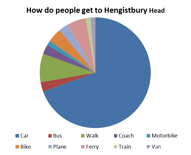
Hengistbury Head attracts tourists from a wide range as showed on page 7. These people use a wide range of transport to get to the Headland as a result of where they come from.
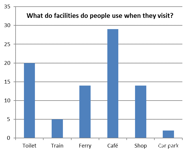
When people go to Hengistbury Head and use a paid facility they contribute towards the local economy by spending money which is an economic reason to keep protecting the Headland. However to get a truly accurate reason I would need to compare the amount of money the Headland brings in and how much it costs to maintain in its current state; the groynes alone cost around £80,000 a year to maintain.

One reason that people come to the Headland is for the natural beauty. Therefore a more attractive Headland should help attract tourists. This graph shows that in its current state, nearly everyone we interviewed thought Hengistbury Head was either beautiful or decent.

While we were visiting Hengistbury Head was asked people if we should continue to protect it. Nearly everyone answered yes which proves that people value to Headland socially.
The Beach huts
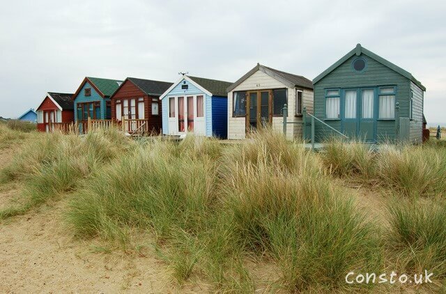
On the spit at Hengistbury Head there are hundreds of extremely valuable beach huts like the ones on the left which can be sold for up to and over £100,000. Because of this these beach huts are some of the most expensive in the UK and due to their tiny size they are also the most expensive properties per m2. This is a major economic reason to protect the spit and Headland.
Christchurch
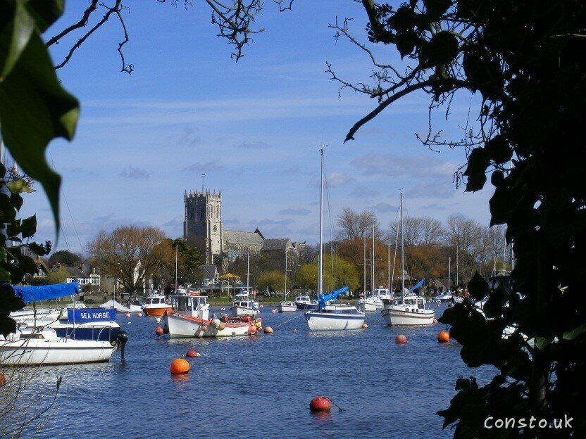
Protected by the spit is the town of Christchurch. This bustling town has a population of over 45,000 people and with many properties, some of these being expensive water front properties which have been sold for nearly £4,000,000. As well as this it has a harbour and all the services you would expect in a town of this size.

This house is being sold for nearly £4,000,000. This is one of many properties on the waterfront which are sold for similar prices which is another reason to continue to protect the Headland and Spit as they protect it and form a natural harbour.
Conclusion
For my coursework it was my job to gather information and form a conclusion in order understand “Why is there a need to protect the Coastline at Hengistbury Head”. In order to do so I firstly need to prove if erosion is happening, then I will need to work out the social, economic and environmental value of it.
When I visited Hengistbury Head and afterwards I collected evidence which shows that erosion is happening. Firstly the old maps show how the spit has clearly shrunk over time possibly due to sand starvation caused by sea defences built west of the spit.
There is also a huge difference when you look at the difference between protected and unprotected coast line in the picture of site 1 which clearly proves that where it isn’t protected gets worn away and weakened compared with when it has been protected and it is strong and solid and in between a gully has formed. Site 2 is unusual; even though the Long Groyne appears to be protecting it there is still erosion. This is due to the wind and water direction and the fact there is only one groyne protecting the cliff; at site 3 there biological weathering. Another sign of erosion is the photo of the unprotected cliff on page 9.
On my cross sections of the beaches on both side of the Long Groyne you can easily see that due to the groyne sand has built up and on the other side the coastline has been starved of it, this helps to support the old maps that I have used and is why one of the sea defences they use is beach replenishment to keep the spit and Headland protected and to keep tourists coming to visit. In addition at site 1 the beach is smooth indicating Long shore drift is taking place.
The Headland has economic value due to the fact that people come from all over the country and a few from all over the world to visit Hengistbury Head, once there they use the facilities such as the Land Train and the shop on the spit which brings money into the area which are both seen on in my photos. As well as this there are beach huts on the spit often valued over £100,000 making them to most expensive pieces of land in Britain per square meter.
Hengistbury Head protects and practically stops the town of Christchurch suffering from erosion unlike towns like Barton on sea which have no protection and are falling into the sea. Due to this house prices along the harbour can be up to and over 3 million pounds with less expensive properties further inland. The harbour itself is an important port.
The headland and salt marshes are home to many rare creatures which is the reason certain parts of it are classed as a Site of Special Scientific Interest. My photos show a meadow which is a place which is highly ecologically valuable, an area which Natterjack Toads live; they are very rare creatures due to reduced habit and acid rain. In addition there is a disused quarry which was once used to mine iron doggers but now is flooded and is home to many species of wildlife. Similarly there have been over 300 bird species sighted visiting.
The Headland and spit are also important socially, with people visiting from all over the world and locally they come to the Headland to relax, go fishing, walking their dogs, visit and relax on the beach and appreciate the areas natural beauty. Some even go bird watching due to the abundance of different bird species living and visiting Hengistbury Head. Due to them enjoying the headland which practically everyone we interviews thought was either decent or beautiful people will come back again and again, each time benefiting the area and the visitor. Over 90% of the people we interviewed had visited before.
In my opinion and the people responsible for the existing sea defences Hengistbury Head should be protected from erosion due to the many different values of the headland, spit and the town of Christchurch which the Headland and spit is currently protecting. It brings in tourists, money, is socially important for the people living nearby and is home to many creatures some of which are rare or endangered. Some people however think that other options such as managed retreat could be a viable alternative to protecting Hengistbury Head and by extension the town of Christchurch due to the cost of maintaining sea defences and improving them as the sea level rises; sea defences are also thought of as unsustainable. It is pricy but if we let the sea erode or flood Hengistbury Head we will put Christchurch in the same danger in the future that some parts of towns like Barton are in where small areas are literally falling into the sea with up to a meter of land being lost a year, destroying the local economy and making the seafront property worthless, this is very different to the current situation is Christchurch.
I feel that I succeeded at proving that there is a need to protect Hengistbury head from erosion with the evidence I collected myself and the information I researched. I could improve my experiment by visiting the site throughout a week to get a more accurate sample of people to survey and by using more sites. I could extend the work by visiting the Headland in years to come to see how the coastline is eroding and what people do about it. Another thing I could do is research a different site such as Barton-on-Sea and see how it compares to Hengistbury Head.
Further Reading
- http://www.old-maps.co.uk for the old maps of Hengistbury Head on page 4.
- http://www.hengistbury-head.co.uk/hengistbury-head-coastal.php for info on page 4.
- Photo of site 2 on page 5 is from the schools collection of photographs.
- https://web.archive.org/web/20111019200601/http://europe-maps.blogspot.com/2011/05/map-of-uk-united-kingdom-political.html for the map on page 10.
- The survey we did while on our field trip for the graphs on pages 10, 12 & 13.
- The ecological score chart on page 11 was completed while we visited the Headland.
- The different bird species on page 12 were recorded by our group when we visited the Headland.
- https://web.archive.org/web/20110722181130/http://www.bournemouth.gov.uk/LeisureCultureLibraries/Parks/Thingstodoandplacestogo/LocalNatureReserves/HengistburyHeadLocalNatureReserve.aspx for the number of bird species on page 12.
- http://station1.highcliffe.dorset.sch.uk/autosite/Binaries/PUBGEOG/h_head.ppt for the cost of maintaining the groynes which I used on page 13.
- http://www.geograph.org.uk/photo/874739 for information and the picture of beach huts on page 14.
- http://www.primelocation.com/uk-property-for-sale/details/id/COCE8570895 for the nearly £4million house on page 14.